

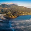

Dr Oliver McLeod is back with new research into underwater volcanoes off the Whāingaroa coast, following the publication of his popular book Geology of Karioi volcano, Aotearoa New Zealand.
The research grew from mātauranga Māori he encountered while exploring Karioi’s geological history, particularly pūrākau about the relationships between Karioi, Pirongia and Kārewa.
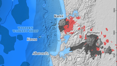
Oliver’s analysis now indicates that many rocky reefs offshore could be the exposed tops of submerged volcanic cones. He identified the probable volcanic features by comparing aeromagnetic survey data with reef locations recorded through the knowledge of commercial fishers.
Pūrākau prompts offshore investigation
The idea began to take shape after a public talk at Raglan Town Hall around 2021, when Angeline Greensill asked how Kārewa fitted into the geological story of Karioi and Pirongia.
Oliver described the question as the “seed of inspiration” for investigating what lay offshore.
He said scientists were often cautious about drawing connections without firm evidence, but pūrākau could still provide valuable insight into how landscapes had evolved.
“Scientists are very conservative people in many ways,” Oliver said. “They kind of live and die on their reputation in terms of being accurate and never drawing links where links don’t exist.”
He said pūrākau could preserve complex information about how landscapes had changed and how different features were connected.
“Pūrākau is codified knowledge,” he said. “It’s a vessel through which knowledge is passed down through generations.”
Oliver said storytelling had long provided a way for cultures to make complicated information memorable. In te ao Māori, relationships between landforms and environmental events could be carried through stories and whakapapa.
In the pūrākau, Karioi and Pirongia are sisters while Kārewa is Karioi’s husband. Following conflict between them, Karioi fled west towards the coast and Kārewa followed, eventually being banished offshore in shame. Their many children were scattered between them, some resting near Karioi and others with Kārewa.
Oliver said the idea of the children had a striking geological parallel. Karioi was the large central stratovolcano, while a number of smaller volcanic cones formed around it, including Kirikiripu Hill near Raglan.
Those smaller volcanoes could be understood as Karioi’s children. The pūrākau also says some of the children remained offshore with Kārewa, raising the question of whether rocky reefs beneath the sea could be their geological counterparts.
“That was the part of the mystery to solve as well, which children are those, because there doesn’t seem to be anything else obvious poking up above the ocean out there, except for Kārewa itself,” Oliver said.
He believed the story may refer to volcanic reefs such as Jackson’s Reef west of Karioi, along with other rocky formations further along the coast.
By describing the smaller volcanoes as children of the larger peaks, the pūrākau records a relationship that is also recognisable in the geology.
Survey data reveals probable volcanic reefs
Knowledge of the continental shelf between Albatross Point and Port Waikato remains limited. Much of the available information comes from oil and gas exploration during the 1970s and 1980s, followed by iron sand surveys in the mid-2000s.
Oliver combined those publicly available datasets with knowledge shared by commercial fishers about the location of rocky reefs.
Aeromagnetic surveys measured variations in magnetism beneath the seafloor. Both iron sand and volcanic rock contain magnetite, but their magnetic anomalies cast different patterns.
Currents move iron sand along the coast, creating magnetic belts that can stretch for several kilometres parallel to the shoreline. Volcanic features appear as smaller, rounded magnetic ‘pimples’, consistent with individual cones or intrusions.
When Oliver compared the survey data with reefs identified by fishers, their locations closely matched.
The likely explanation is that many of the reefs are the remains of small volcanic cones associated with the wider Karioi-Okete volcanic system. Although much of each cone may now be buried beneath seafloor sediment, its rocky summit can still protrude above it.
“The level of detail in the aeromagnetic survey is remarkable,” Oliver said.
It was detailed enough to also reveal possible lava flows and explosion craters beneath the continental shelf. In searching for iron sand, the survey company had inadvertently mapped a submerged volcanic landscape.
Oliver is preparing a scientific paper on the findings, which could change understanding of how volcanic activity migrated north over the past 2.6 million years towards the present-day Auckland volcanic field.
Rocky reefs may be ecological refuges
The discoveries may also be important for marine ecology.
Although much of the continental shelf is relatively flat and covered in sandy sediment, volcanic cones create isolated areas of rocky habitat.
“They’re like little islands of ecology in a relatively featureless landscape,” Oliver said.
These areas could provide refuge for marine species, making it important to know where they are located, particularly during discussions about seabed mining.
Oliver said detailed bathymetric surveys were needed to show the shape of the seafloor more clearly. A more affordable next step would be to use drop cameras to investigate sites identified as probable reefs.
Existing footage from Jackson’s (Patuatini) Reef, Kārewa and other locations near Karioi has already provided a glimpse of the ecosystems supported by these formations.
Bringing Karioi’s past to life
Oliver is also helping Raglan Museum develop a natural history exhibition about Karioi, expected to open in mid to late 2027. It may include digitally generated reconstructions showing how the mountain and surrounding landscape could have appeared millions of years ago.
He said such images offered another way to communicate complex geological information and make the changing landscape easier to visualise.
Oliver said the next step was to investigate more of the probable reef sites and build a clearer picture of the volcanic landscape hidden off the Waikato coast.